
Iowa Map
 |
 |
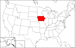
Where Is Iowa?
Iowa's location is highlighted on this 50 state map. The State of Iowa is bounded by Minnesota on the north and by Missouri on the south. Iowa is bordered on the northeast by Wisconsin and on the southeast by Illinois. It is bordered by South Dakota on the northwest and by Nebraska on the southwest.
Iowa Maps
Iowa is the 23rd largest state in the United States, covering a land area of 55,869 square miles (144,701 square kilometers). Iowa is divided into 99 counties. This Iowa map site features road maps, topographical maps, and relief maps of Iowa. The detailed, scrollable road map displays Iowa counties, cities, and towns as well as Interstate, U.S., and Iowa state highways. The pannable, scalable Iowa street map can be zoomed in to show local streets and detailed imagery.
Iowa Highway Map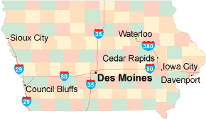 Click on the highway map thumbnail
to view a scalable Iowa road map. |
IA Topo Map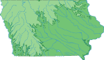 Click map to enlarge.
|
IA Relief Map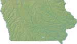 Click map to enlarge.
|
The detailed Iowa map and the regional Iowa map display cities, roads, rivers, and lakes as well as terrain features. The detailed map shows only the State of Iowa, while the regional map shows Iowa and the surrounding region.
Iowa Infrastructure > Iowa Airports
In 2005, the population of Iowa was estimated at 2,965,524, which is about 53.1 people per square mile. In 2010, Iowa's population rose to 3,046,355 people. More recently, in the 2020 census, the Iowa population was 3,190,369. Iowa's primary Interstate Highways include I-29, I-35, and I-80, as well as auxiliary route I-380.
Iowa Topography and Historic Sites
Iowa is named after the Ioway Indians who once inhabited the area. Iowa's prairie farmlands are known for their deep, fertile topsoil. In eastern Iowa, the terrain is fairly level, but in western Iowa the flat prairie gives way to hilly terrain. Primary tourist attractions include the Amana Colonies, Fort Dodge Historical Museum, Living History Farms, and the Herbert Hoover National Historic Site. For more Iowa travel and tourism information, please visit the official Iowa tourism site and Iowa Atlas.
Other Iowa Maps
This online Iowa reference map shows major cities, roads, railroads, and physical features in Iowa.Several map publishing companies offer printed maps of Iowa. For example, Omni Resources offers several maps of Iowa that feature points of interest, airports, and parks, as well as selected local attractions and insets of major Iowa cities.
All rights reserved.
Certain maps hereon are © Map Resources or Digital Wisdom.
To facilitate browsing, certain external links will open in new windows.
Iowa-Map.org Editor, State Maps, PO Box 828, Barnegat, NJ 08005.